Ridgewood Evacuation Routes
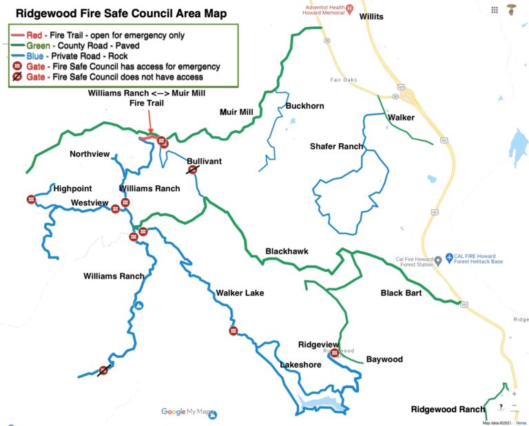
In addition to the roads outlined on the map, we have arrangement with 6 private landowners who have volunteered access to routes across their land if needed in an emergency. The Fire Safe Council has access to open these routes, and will check on their condition at the start of each fire season. These are often dirt roads in rough shape, we are working on determining minimum clearance and whether these require 4WD. They have been shared with the Sheriff/CalFire. However due to privacy concerns with the landowners, we cannot share the locations ahead of time.
Private evacuation routes connecting:
- Westview/Highpoint area with the 20
- Muir Mill area with the 20
- Walker Lake area with Ridgewood Ranch
- Shafer Ranch area with the 101
- Blackhawk Rd with Shafer Ranch
We are working with additional landowners to
add more routes, and improve existing ones.
The Sheriff (in cooperation with fire and other local personnel) determines what route is going to be designated for resident evacuation and which will be for emergency personnel to use. The most likely scenario will be that evacuation will be to the East using the paved county road you normally use, fire departments will use the alternate access roads to come in. If the main county roads (Blackhawk, Black Bart, Muir Mill) are blocked the Sheriff will designate alternate route(s). If one of the private routes are determined to be an evacuation route we will announce the location through REN, will open up the gate, and put up signs (once purchased…please donate here so we can purchase them! https://ridgewoodfsc.